Quality Assurance/Quality Control
Field Data Hints
The following are some simple things that can help protect the quality and integrity of data collected in the field.
- Take digital photos as a backup copy of data:
- Photo of GPS can be used to correct transposition errors in manual recording. Even better, also save the location as a "waypoint" ("POI" - point of interest, or "mark") and transfer the data electronically later. However, the manually written or photographic back up copy is still a good technique to protect against a single point of failure causing the loss of the data.
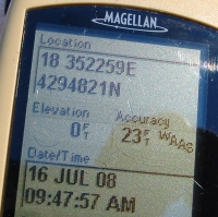
- With the consumer grade GPS shown in the photo, the display includes accuracy that it did NOT save in the data files for waypoints or tracks.
- Photograph or photocopy field notebook pages regularly. Loose data collection forms are easy to misplace, so copies can prove to be particularly valuable.
- When planning to geolocate photos taken with a digital camera with a track recorded on a GPS unit, take one or more photos of the GPS clock to permanently record any difference between the GPS and camera clocks. With my first digital camera, it only recorded the photo time to the nearest minute, so I took photos of the GPS clock (showing seconds) about every 10 seconds so that I could approximate the synchronization to within that 10 second tolerance. This was less than ideal, but better than a single image. After replacing that camera with a more waterproof one, the problem was solved since the newer camera recorded photo times to the nearest second. My latest camera has a built in GPS making this recommendation obsolete.
- Based upon a non-quantitative analysis, it seems that black Sharpie brand marker ink is more resistant to fading in sunlight than red, blue, and green ink. This accidental discovery was made trying to read labels written on wooden stakes several years later. My hypothesis is that black ink is colored with carbon which is more stable than the organic dyes in the colored ink. Proof of this hypothesis is left as an exercise for the reader.
- The Data Entry Guidelines page in the Information Technology section provides additional recommendations for maximizing ease of entry into computer systems while minimizing the occurrence of data entry errors.